
Ponders End
Ponders End is a former Lea Valley hamlet in the London Borough of Enfield, centred on its High Street, Ponders End station and the River Lea, with a Grade II listed flour-mill group.
Area guide
Living in Ponders End
Ponders End is on the eastern edge of the London Borough of Enfield, in the EN3 postcode district, between the main railway line and the Lea Navigation and reservoirs that form the border with Waltham Forest. Enfield Council's conservation area appraisal says that until the mid-19th century the Lea Valley here held isolated hamlets, including Ponders End, Enfield Wash and Enfield Highway, which railway and industry later joined into a continuous suburb. Ediswan took over a former jute mill at Ponders End in 1886 and made electric light bulbs and later radio valves. The Wright's flour mill group on Wharf Road, now a conservation area, includes Grade II listed buildings of the 18th century.
Housing in the area is mixed. The council's appraisal describes residential tower blocks on the west side of the railway, with industrial and warehouse land to the north, south and east. The council has treated Ponders End as a regeneration priority area. Its Electric Quarter scheme on the High Street provides 167 homes in two phases, with community and commercial space, and the council's Ponders End pages also cover the Alma Estate redevelopment. Ponders End Park, a recreation ground with an entrance on the High Street, is a local green space.
Ponders End station is in Zone 5 and is run by Greater Anglia on the Lea Valley line between Tottenham Hale and Cheshunt. TfL's journey planner shows a direct Greater Anglia service to London Liverpool Street, and Tottenham Hale has a Victoria line station. Brimsdown, also Zone 5, is the next station to the north. There is no Tube station in Ponders End. The A110 Lea Valley Road and the A1055 Meridian Way pass close to the mills.
Transport
Getting around Ponders End
Ponders End station is on the Greater Anglia Lea Valley line between Tottenham Hale and Cheshunt, and TfL's journey planner shows a direct service to London Liverpool Street. The A110 Lea Valley Road and the A1055 Meridian Way run close to the mill site.
Ponders End
Greater Anglia · Zone 5
Station managed by Greater Anglia on the Lea Valley line between Meridian Water and Brimsdown.
Brimsdown
Greater Anglia · Zone 5
Next station north of Ponders End on the same line.
Parks, shops and schools
What Ponders End has nearby
Parks and green space
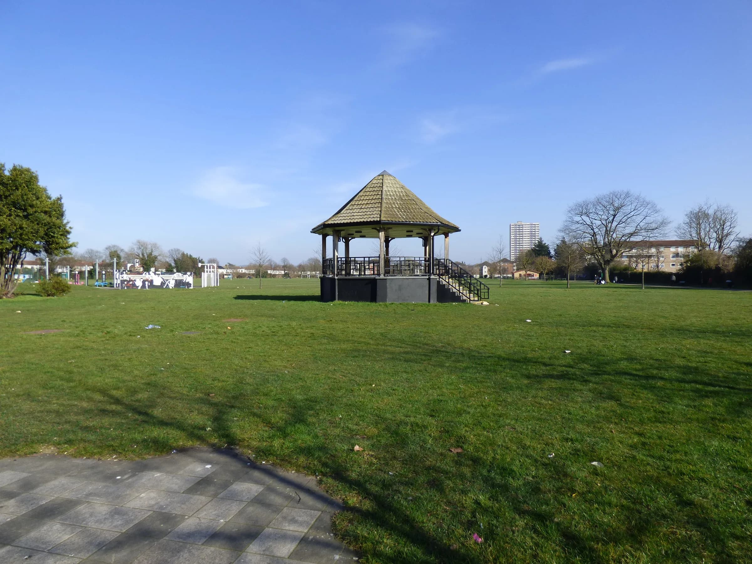
- Ponders End Park (opens in a new tab)Council recreation ground off the High Street with a bandstand, sports facilities and an outdoor gym; Fields in Trust protected.
- Lee Valley Regional Park (opens in a new tab)26-mile, 10,000-acre regional park along the River Lea, passing the east side of Ponders End.
High street and shopping
Ponders End High Street is the main local street, and the council's Electric Quarter scheme on it adds new homes, community space and commercial units.
- Ponders End Park entrance
- Electric Quarter
Schools
State schools in Ponders End are the responsibility of the London Borough of Enfield as local education authority. Use the official tools below for admissions rules and school information.
A little history
Ediswan took over a former jute mill at Ponders End in 1886 and made electric light bulbs and later radio valves, and set up Britain's first radio valve factory there in 1916. The Ponders End Flour Mills conservation area was designated in 1970 around a group of late 18th-century mill buildings listed Grade II.
Local favourites
Worth knowing in Ponders End
Roads and pockets
- High Street — the main street, with the entrance to Ponders End Park and the Electric Quarter regeneration scheme
- Wharf Road — address of Wright's flour mills, a group of Grade II listed 18th-century buildings in a conservation area
- Electric Quarter, High Street — a council-led development whose name acknowledges the area's history of industrial innovation
- Lea Valley Road — the A110, which runs east-west just north of the mills conservation area
Places worth a visit
- Ponders End Flour Mills conservation area — a mill group beside the River Lea, designated in 1970, with a Grade II listed mill, mill-owner's house, office house and timber barn (in private ownership per the council's 2015 appraisal)
- Ponders End Park — a recreation ground opened by Enfield Urban District Council in the 1920s, with a bandstand and formal entrance planting on the High Street
- Lee Valley Regional Park — a 26-mile regional park running along the River Lea to the east of Ponders End
- Lee Valley Walk — a recreational path along the eastern bank of the Lea Navigation that passes the mills conservation area
Compiled from public sources such as council guidance and local history records, and reviewed October 2026. These are not recommendations or valuations.
Property market
Property prices in Ponders End
Median sold price
£410,000
245 sales in the 12 months to July 2026
| Property type | Median | Sales |
|---|---|---|
| Semi-detached | £447,500 | 42 |
| Terraced | £429,000 | 120 |
| Flats & maisonettes | £252,500 | 76 |
Based on completed sales registered at postcodes in EN3, which only approximate the area's boundaries and include sales we did not handle. Standard (category A) residential sales for value only: the Land Registry’s category B, which includes repossessions, buy-to-lets identified by a mortgage and sales to non-private individuals, is not counted. Contains HM Land Registry data © Crown copyright and database right 2026. This data is licensed under the Open Government Licence v3.0.
Available now
Homes in Ponders End
Questions
Ponders End: common questions
Quick answers about living in and moving to Ponders End.
Which council covers Ponders End and who sets council tax?
Ponders End is in the London Borough of Enfield and Enfield Council bills Council Tax. The postcode district EN3 lies in the borough, but check a specific address on the council's website.
Which station serves Ponders End and what zone is it in?
Ponders End station is in Zone 5 and is managed by Greater Anglia on the Lea Valley line. TfL's journey planner shows a direct service to London Liverpool Street. Brimsdown, the next station north, is also in Zone 5.
Is there a Tube station in Ponders End?
No. TfL's station search shows no Underground station named Ponders End. Tottenham Hale, on the same rail line to the south, has a Victoria line station.
Which postcode district covers Ponders End?
Ponders End is covered by the EN3 postcode district. Nearby areas use N9 and EN1, and the border with Waltham Forest lies to the east beyond the reservoirs.
What green spaces are near Ponders End?
Ponders End Park, with its entrance on the High Street, is the main local park and is protected under the Fields in Trust Queen Elizabeth II Fields scheme. The Lee Valley Regional Park, a 26-mile regional park along the River Lea, lies to the east.
Location
Where Ponders End is
Nearby
Nearby areas
Value my property
Selling or letting in Ponders End?
Talk to our local team about the market in Ponders End — book a free, no-obligation valuation or call the office.